
The Welland Canal is a man-made waterway that flows through the Niagara Region, connecting Lakes Erie and Ontario. While the canal has had a strong role in the history of the city of Welland and the fellow cities surrounding it, the Fourth Welland Canal (1932-1972), also referred to as the Welland Ship Canal (Welland Public Library, 1973), was a very significant era for the Niagara Region. As the demand for materials increased and there was a necessity for ships to make their way into and through the city of Welland (Martine, 1961), the Canal was widened manually, resulting in the creation of the Welland Ship Canal. Although this allowed ships to by-pass Niagara Falls, there was an increase in cargo traffic through Welland, specifically around the year 1959 (Neil, 1965). When focusing on the area ranging from Townline Tunnel Road in the South of Welland to Merritt Island in the North, it is visible that the city of Welland has evolved in accordance with the Welland Canal. The city shifted from being a predominantly agricultural land to an industrial part of Niagara, continuously expanding with the Welland Canal at its core. Although Welland was once a thriving city that relied on the large body of water found at its centre, the present-day city no longer relies on the frequently-passing vessels which once allowed the primary inflow of goods for citizens and industries (Martine, 1961). In fact, cargo and other large ships no longer pass through the core of Welland, rather, they utilize the Welland By-Pass Channel (Gayler & Jackson, 2007). As time has progressed, the downtown portion of Welland has shifted to a rather urban landscape, attracting individuals with its various restaurants and natural spaces, found alongside the canal. In addition to its functional use, the Welland Canal and the city of Welland have had many effects on the transformations of one another, specifically in terms of their ecology, geomorphology, climates, and historical features.
Municipality: Welland
Local area name: Downtown Welland
Other identifying names or descriptions Waterway
Latitude and longitude: 42 degrees , -79 degrees
Physical Dimensions
Length: 3512 m
Width: 94.5 m
Surface Area: 331,884 m2
Elevation:
Highest / lowest point: 175 m
The Welland Canal is a body of water that has been created and transformed manually in order to provide access for cargo ships into the Niagara Region, specifically as a way of travelling between Lake Erie and Lake Ontario (Neil, 1965). The area which has been chosen to analyze in this report is that which is found in the city of Welland between the Welland International Flatwater Centre and the Aqueduct at Merritt Island. While this area is only a small portion of the canal, it is capable of demonstrating the changes which have occurred throughout the city of Welland as it was once a thriving industrial city (Martine, 1961). During a certain point in the history of the Welland Canal, namely the era of the Fourth Welland Ship Canal, there was a large number of ships passing through Welland in order to provide industrial materials and necessities for the residents of Welland. Specifically, at the time of the completion of the Saint Lawrence Seaway, cargo traffic had significantly increased (Neil, 1965). This caused the need for a new by-pass on the outskirts of Welland.
In the present day, the core of Welland shows evidence of both an increase in residential areas and a decrease in industrial advancement, as visible in Figure 2. Although the canal continues to remain present in Welland, the bridges that once raised to accommodate large ships are no longer functional in this sense. Bridges and streets now solely provide access to vehicles and pedestrians from one side of the city to the other. In addition to this, the land surrounding the Welland Canal in downtown Welland possesses many trails and parks as well as other recreational spaces. These features allow individuals and families to engage in physical activity and enjoy the recreational spaces that Welland has to offer.
Map 1:The Welland Canal (centre) and its surrounding area ranging from the Welland International Flatwater Centre to Merritt Island. The Welland River is also visible on the left while the Welland By-Pass Channel is found on the far right.

As a result of the Welland Canal being a body of water, there are many organisms found within and around this landscape. Along the territory found along the canal, the plant species appear to be primarily native to the land. For instance, there are a variety of untamed flowers and shrubs, many of them being hydrophilic species. These species are untamed, creating a certain natural sense of place to this landscape as it remains untouched by human influences. As for trees, there are a variety of species found in the surrounding aquatic area. Weeping willows, maple and oak trees, as well as blue spruces can be seen, creating a similar a sense of natural aesthetic for individuals to enjoy, as with the flowers and shrubs, in addition to the possibility for the habitation of animal species. Although many of these species of trees may have been planted by the city of Welland as time has progressed, others, such as the weeping willow, are quite hydrophilic trees. This being said, it is possible that the weeping willows specifically are native to the canal's surroundings.
Through the maintenance and horticulture within this area, the city of Welland is able to create a welcoming space for recreational activities and enjoyment of the Welland Canal. Maintenance and horticulture are especially visible in Figure 3, an honorary memorial monument located in the downtown sector of Welland, along the water. This memorial represents the people who took part in the construction of the Welland Canal (Welland Heritage Advisory Committee). In spaces such as these, it is apparent that there is a prioritization of horticulture. Hough defines this term as "the art or science of cultivating or managing gardens – embodies the ideal of nature under control" (Hough, 2004, p.92). In other areas of downtown Welland where there is lower visibility from vehicles and pedestrians, for example along the trail, plant species are found in their natural state without modification. This demonstrates that the city considers areas in more frequently visited spaces to be more worthy of maintenance. For example, the monument in Figure 3 that is located across the street from the Welland Historical Museum is constantly being maintained and controlled. This creates a sense of cleanliness and care to the public. As explained by Hough (2004), weeds specifically are simply "plants growing where they are not wanted" (p.13). This claim is solidified in the case of the memorial monument where weeds are prevented from growing in order to demonstrate an up-kept aesthetic. Aesthetics are quite relevant for a landscape when it comes to the attraction of local populations as well as tourists (Farina 2006). With this being the case, the city of Welland's maintenance of the downtown sector alongside the canal creates an inviting space for all individuals who are visiting the waterway.
When focusing on the species of animals that are found in the area, there are large populations of ducks and Canadian geese as a result of the landscape being a waterway. In addition to these two dominant species, there is a presence of squirrels and fish as well. While these species of animals are not only found in the vicinity of the canal, the presence of both a large body of freshwater and shrubbery creates a welcoming environment for these species and their desired habitats. The Niagara Region as a whole is a rich habitat for birds (Brown et al., 2010). However, of 25 endangered bird species in Ontario, three are found in the Niagara Peninsula in addition to two species which are considered to be of special concern (Brown et al., 2010). With this being the case, the Welland Canal and other bodies of water within the region must ensure safe conditions for these species. This is possible through the protection of the Welland Canal and its surrounding natural lands.

During the last ice age which began 23 thousand years ago, the Niagara Region and Canada as a whole were covered in a layer of ice. As the ice began to melt, the Five Great Lakes began to be formed through the process of the water being held in hollowed areas where glaciers had originally formed (Brown et al., 2010).
More recently, the demand for a method of transportation that by-passed Niagara Falls was required. The Welland Canal was then formed in the year 1829 (Albanese & Westwater, 2014), creating a method of transportation for ships from Lake Erie to Lake Ontario and vice versa.
While the Welland Canal is an aquatic landscape, its surrounding lands are made up of soil. The Niagara Region possesses high-quality soil, causing it to be an ideal location for agriculture. Whereas the soil within Niagara was primarily clay in the past, it has developed into what is called sandy loam (Brown et al., 2010). This predominantly sandy soil has allowed proper drainage and, in consequence, has led to higher-quality soil for agriculture. As previously stated, there has been a shift within Welland from agricultural land to property that is used for industrial and residential purposes, as visible with the evolution of Welland's core in Figure 2. Therefore, it is evident that while certain areas in Niagara have remained agriculturally dominant, others such as Welland have had a change in demands, resulting in a shift of priorities.
In the 1800s, the Welland Canal was first constructed (Welland Library). While this was not a natural occurrence and rather a planned construction in order to provide proper access from one lake to another, this construction caused changes in the land to occur. A new waterway was created through Niagara's land, causing a change in the geomorphology and ecosystems within the area. For instance, the construction of a waterway has allowed various hydrophilic species to migrate into the area. This includes Canadian geese and other species of birds, as discussed above.
As a result of the Welland canal being a body of water, it is evident to state that the chosen landscape is strongly related to hydrogeology. However, the topic of hydrogeology is much more profound, causing various discussions concerning the Welland Canal to arise. During the Third Welland Canal's expansion which originally began in 1913 (Welland Public Library), resulting in the creation of the Fourth Welland Canal, many changes took place and continued to occur after this era.
After decades of the Fourth Welland Canal being the mode of transportation for the ships that passed through Welland and other cities in the Niagara Region, the canal was found to be causing a high traffic of vessels within the area. The By-Pass Channel was then created in order to provide a shorter travel time for ships to by-pass Niagara Falls (Welland Public Library). As a result of the canal no longer being utilized for large ships, all lift bridges were replaced or modified in order to be used merely for vehicle and pedestrian access to the other side of town. Overall, the present canal has been converted from a highly utilized waterway to one that is used for recreational means within the city.
In the past, especially during the 1960s and 1970s, water contamination within Lakes Erie and Ontario was at a high. Results of chemicals from industrial and agricultural sources caused many concerns relating to water quality for the Niagara Region and Southern Ontario (Brown et al., 2010). Despite the Welland Canal being excluded from this list of polluted water sources, both lakes are, in fact, found at the endpoints of the canal. In other words, the canal's connections to these two lakes could have caused a risk for contamination as pollutants travelled into the region's waterway.
During the early periods that followed the most recent ice age, climates in the Niagara Region, including the city of Welland, were much graver. In the last century, summers and winters have come to be much milder (Brown et al., 2010). The Great Lakes, specifically Erie and Ontario in the case of Welland, cause exposure to breezes which moderate climates (Brown et al., 2010). Although Welland is not directly located along the lakes, the Welland Canal's connection to the lakes may cause winds to travel across itself and into the city. Therefore, it is evident that the presence of bodies of water strongly affects a city's climates. Wazneh et al. (2017) demonstrate the results of a study relating to the history of climates in Southern Ontario. On page 2781, a set of four graphs are shown, showing the annual wet and dry days from 1950 to 2013. As visible through these graphs, while there are slight variances in the climates as time has progressed, there seems to be quite a stability for Southern Ontario's climates. This being said, regardless of changes in climates within other areas, Southern Ontario seems to have remained relatively similar when comparing with its climates in the 1950s.
Archaeological Influences:
Prior to European settlement, Indigenous peoples of the Neutral Nation settled within the Niagara Region (Brown et al., 2010). In consequence of the region's suitable agricultural land and waterways, Indigenous peoples could have been attracted to the area specifically for fishing and agricultural purposes. However, as a result of the Welland Canal being built in the 1820s (Albanese & Westwater, 2014), Indigenous settlers would not have been exposed to this landscape directly.
It has been noted by the Welland Heritage Advisory Committee that Indigenous peoples had great influence during the time of the construction of the Fourth Welland Canal. Although some of these individuals may have travelled to Welland in order to assist in the construction, many may have been descendants of local settlers. As cities within the Niagara Region began to grow as a result of urbanization and attraction to the canal for employment, they became some of the most ethnically diverse cities in Ontario (Patrias, 2018). Therefore, it is important to recognize the influences that Indigenous peoples have had on both the Welland Canal and the Niagara Region in its totality, as well as acknowledge their lands which have allowed the Welland Canal to be constructed.
Land Use History:
Once the Welland Canal was built, Welland's population began to rise and, as a consequence, the city began to expand. As industrialism and the transportation of goods – food, energy, transportation, etc. (Alberti, 2008) – became more prominent through means of cargo, the construction of the Fourth Welland Canal was necessary (Neil, 1965). This construction caused many immigrants to be drawn to the region, mainly for employment within this sector (Patrias, 2018). In 1931, one year prior to the completion of the Fourth Welland Canal, the population of Welland was 10,709 (Patrias, 2018) whereas in a more recent census in 2016, there were 52,293 individuals residing in Welland (Niagara Region). These statistics show a major increase in population within the past 85 years. Not only did the impacts of the Welland Canal cause growth in Welland (Gayler & Jackson, 2007), but Niagara experienced an increased demand for residential areas after World War II (Brown et al. 2010). Figure 4 and Map 2 show the growth that has occurred between 1934 and 2010, especially in the vicinity of the waterway. The development patterns within these images – the higher density of residences along the canal – had many positive impacts on the residents of Welland; this includes a shorter travel distance for individuals who were employed at or around the Welland Canal (Marzluff, 2008).
In many areas such as the lower-left corner in Figure 4 and Map 2, there has been a shift from a rather agricultural use of land to an urbanized one. Hough (2004) discusses this point in relation to land that was once used for farming which has now produced housing. This shows that Welland is amongst many lands that have experienced a drastic change when it comes to their historical functions. When analyzing Figure 4 and Map 2, it is noticeable that there are many agricultural lands in the top left portion of Figure 4. However, 76 years later in Map 2, there are nearly no agricultural spaces or large open spaces, in general.

Education / Interpretation:
In the core of downtown Welland, the Welland Historical Museum and Welland Public Library can be located and utilized. Both of these resources provide a variety of photos as well as information relating to the Welland Canal and its history. When discussing the canal in general terms, there is often an undermining of the fact that the canal has had such an influence on the city of Welland as well as Niagara. With the assistance of resources such as those provided within and through the websites of the museum and library, it is possible to gain a proper understanding of the current waterway and its evolution and impacts throughout history.
As for information and photos relating to the Welland Canal and its relations to the other cities found along the waterway, for example, St. Catharines and Port Colborne, websites such as the one listed below in addition to the municipal websites, libraries, and museums of these cities provide thorough information relating to the influential canal.
http://www.niagarawellandcanal.com/
While various heritage buildings and architecture were built in the 1800s, others were constructed during the period of the Fourth Welland Canal and remain significant in the present day.
The primary piece of heritage for the city of Welland is the Main Street Bridge (Bridge 13). Built during the late 1920s, as shown in Figure 5, the bridge eventually opened to cargo and vehicle traffic in 1930 (Welland Heritage Advisory Committee) as the Fourth Canal was still being constructed. The Welland Heritage Advisory Committee has stated that Bridge 13 is "one of only two structures in Welland to have been built almost entirely by members of the First Nation." The commemorative memorial from Figure 3 was unveiled in 2001 as a way of thanking all individuals who had helped construct the Welland Canal (Welland Heritage Advisory Committee), including the Indigenous peoples. While the bridge was raised for the last time in 1972 (Welland Heritage Advisory Committee), it has not been transformed since. The bridge holds significant importance for the history and representation of both the city of Welland and its canal. This being said, as visible in Figure 6, the bridge is currently well maintained in order to protect this valuable piece of architectural heritage.
In addition to the Main Street Bridge, the Welland Historical Museum, located on King Street, was a significant location during the time of the Fourth Welland Canal. The Welland Heritage Advisory Committee refers to this location as the Carnegie Building. In 1923, the Carnegie Library was completed and remained Welland's public library until 2005 when the library was moved to a nearby location. Today, this significant building is the Welland Historical Museum, holding various information and photos of Welland throughout history, including Figure 5.
The following link is an excellent additional resource, providing many heritage photos of Welland and the Welland Canal throughout its past: https://www.welland.ca/Heritage/pdfs/ReminiscingAboutWelland.pdf (City of Welland Heritage Advisory Committee & Welland Historical Museum)
Recreational Uses:
As time has progressed and the Welland Canal in downtown Welland has shifted to a space for rather recreational use, many activities for the benefit of citizens have taken place.
In addition to the Welland International Flatwater Centre (Figure 7), docks found along the canal allow individuals as well as groups to enjoy activities such as rowing and kayaking. Although many of these sports occur on a casual basis, certain rowing tournaments have taken place at the Flatwater Centre, making use of the canal in a more formal way.
Aside from these water sports, the city of Welland has provided a trail alongside the canal which encourages physical activity and the enjoyment of natural spaces without being within the water. It is visible in Figure 1, however, that there is an absence of proper lighting along this trail. This causes a concern for safety (Hough, 2004), specifically when travelling autonomously during the late evening or night. Not only does this create a higher risk of crime in addition to the feeling of worry for many, but there may also be a higher risk of collisions between pedestrians and cyclists, for example. The city of Welland has also provided benches and picnic tables along the trail, as shown in Figure 9, as well as at the Welland International Flatwater Centre. This can increase a positive sense of place for many as they can spend time resting and enjoying nature comfortably.
The city of Welland has also more recently implemented an amphitheatre in the downtown sector, as visible in Figure 8. This recreational space with adequate seating has allowed concerts and events to take place in a way that demonstrates admiration for the Welland Canal.
Map 3: Pin of the Trail Along the Welland Canal in Downtown Welland, ON


Ownership, Jurisdiction, Access, and Management:
The Welland Canal is an important part of the Saint Lawrence Seaway, causing the authority of navigation and ownership to belong to the Saint Lawrence Seaway Management Corporation. However, during the earliest days of the canal's construction in the 1820s, the Welland Canal Company had a primary role in construction and modifications to the canal (Welland Public Library).
When focusing specifically on the lands surrounding the canal within the city of Welland, the Welland Recreational Canal Corporation possesses management. This means that the WRCC ensures a clean outdoor space along the canal while also focusing on the horticulture of the land. Although public access is permitted, the city of Welland has enforced a by-law that prohibits motorized watercraft within the canal without written consent from the WRCC to do otherwise (Corporation of The City of Welland, 2005).
Navigation authority: Saint Lawrence Seaway Management Corporation
Original owner: Welland Canal Company (Neil, 1965)
Management of Recreational Canal lands: Welland Recreational Canal Corporation
While the city of Welland is surrounded and divided by three major waterways, namely the Welland River, Welland Canal, and Welland By-Pass Channel, it was not always this way. Although the Welland Canal began being built in 1825 (Albanese & Westwater, 2014), the By-Pass Channel was built and completed in a more recent time, specifically in 1973 (Albanese & Westwater, 2014). This being said, Welland has possessed a certain advantage by being surrounded by these bodies of water.
It is important to recognize that the Welland Canal does, in fact, pass through various cities within the Niagara Region. As a consequence, these cities are connected through their access to the canal. In the previous decades of the Fourth Welland Canal, prior to the By-Pass Channel, ships were able to provide resources to these cities through their shared waterway. When focusing on a larger perspective, the Welland Canal connects Lakes Erie and Ontario. Lake Ontario then connects to the St Lawrence River and the Gulf of St Lawrence (Google Maps, 2020). This solidifies Hough's (2004) statement that everything is connected to everything else. Although the Welland Canal is relatively small in size, its relation to larger bodies of water clearly demonstrates its importance on the larger scale. Without the presence of the Welland Canal prior to the construction of the By-Pass, the Niagara Region as well as Welland specifically would not have had direct access to goods from external sources. In addition, cargo ships would have been unable to by-pass the Niagara Falls (Gayler & Jackson, 2007).
City of Welland Heritage Advisory Committee
c/o City of Welland
60 East Main St.
Welland, ON L3B 3X4
Email: info@wellandheritage.ca
St. Lawrence Seaway Management Corporation
508 Glendale Avenue
St. Catharines, Ontario
Canada L2R 6V8
Tel: 905-641-1932
Fax: 905-682-4525
Vessel Location:
905-688-6462
Website: https://greatlakes-seaway.com/en/
City of Welland
Bridge Maintenance - 905-735-1700 ext. 3000
Tree trimming, grass cutting, road side grass cutting (on city property) - 905-735-1700 ext. 3000
Utility Construction, Canal Lands - 905-735-1700 ext. 3000
Website: https://www.welland.ca/Inquiries.asp
Albanese, L. & Westwater, G. (2014). Welland Canal History. Welland Canals. http://wellandcanals.ca/History.html
Alberti, M. (2008). Advances in Urban Ecology Integrating Humans and Ecological Processes in Urban Ecosystems. Springer. https://link-springer-com.proxy.library.brocku.ca/book/10.1007%2F978-0-387-75510-6
Brown, D. T., Middleton, J. & Vaughan, K. S. (2010). The Land Between the Lakes – An Overview of the Niagara Region.
City of Welland Heritage Advisory Committee & Welland Historical Museum. Reminiscing about Welland. Welland Ontario Canada. https://www.welland.ca/Heritage/pdfs/ReminiscingAboutWelland.pdf
City of Welland Heritage Advisory Committee. (2020). Carnegie Building. Welland Ontario Canada. https://www.welland.ca/Heritage/CarnegieBuilding.asp
City of Welland Heritage Advisory Committee. Main Street Bridge. Welland Ontario Canada. https://www.welland.ca/Heritage/tour_info/tour1.jpg
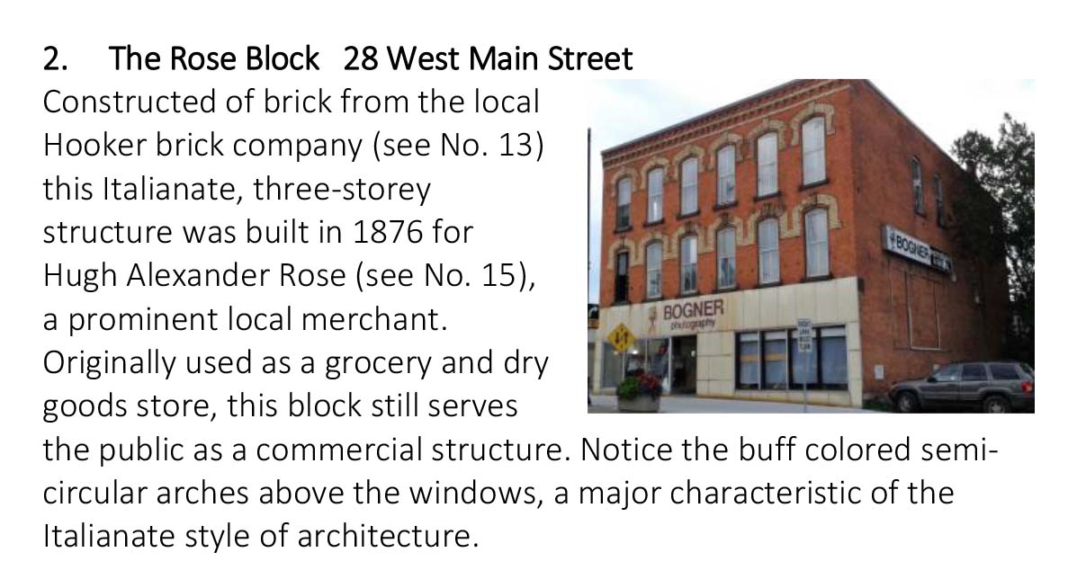
City of Welland Heritage Advisory Committee. The Rose Block 28 West Main Street. Welland Ontario Canada. https://www.welland.ca/Heritage/tour_info/tour2.jpg
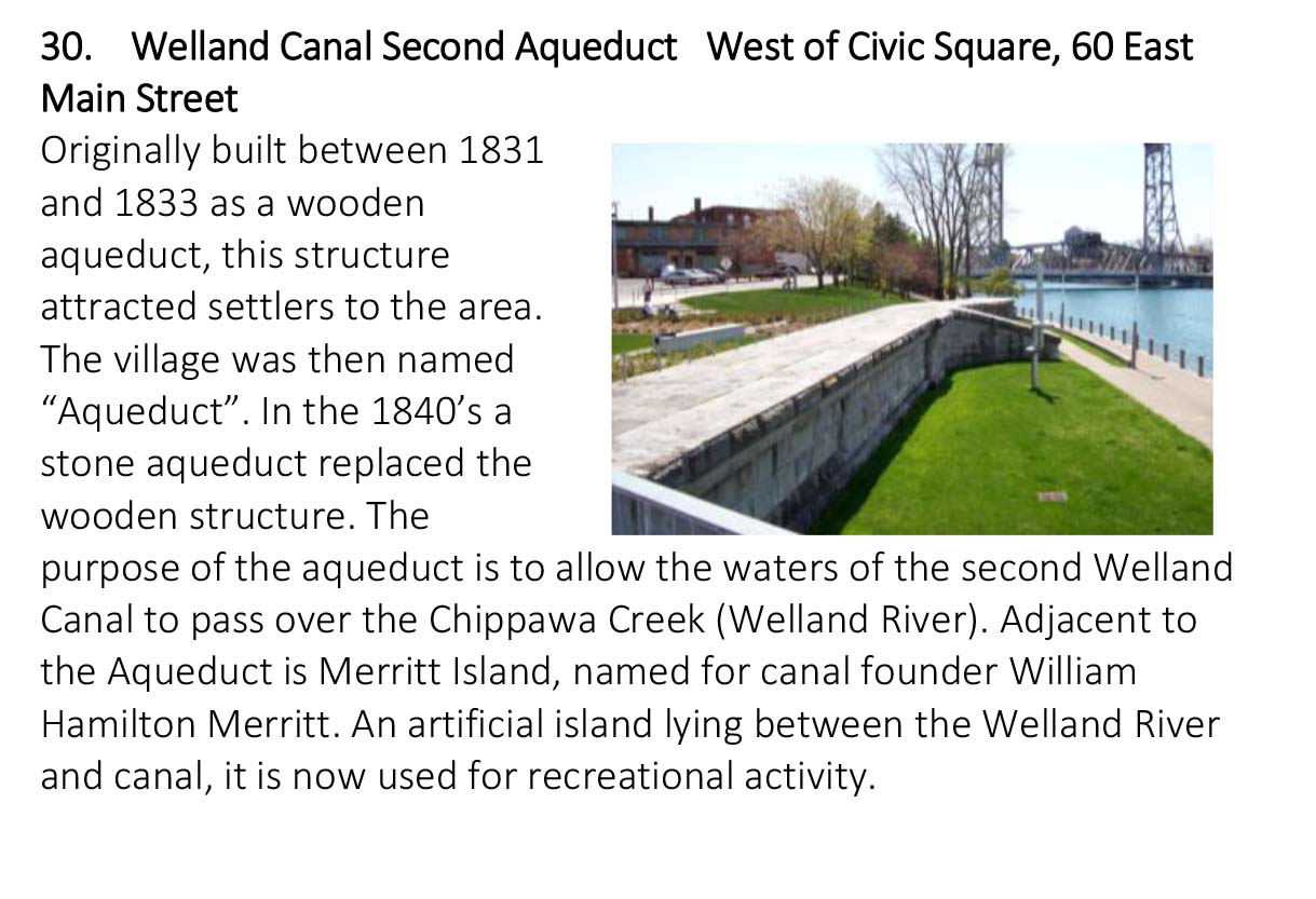
City of Welland Heritage Advisory Committee. Welland Canal Second Aqueduct West of Civic Square, 60 East Main Street. Welland Ontario Canada. https://www.welland.ca/Heritage/tour_info/tour30.jpg
Farina, A. (2006). Principles and Methods in Landscape Ecology. Springer. https://link-springer-com.proxy.library.brocku.ca/book/10.1007/1-4020-3329-X#about
Gayler, H. & Jackson, N. (2007, January 29). Welland Canal. The Canadian Encyclopedia. https://www.thecanadianencyclopedia.ca/en/article/welland-canal
Google Maps. (2020). Welland Canal, Welland, ON [Digital Map]. Google Maps. https://www.google.ca/maps/place/Welland+Canal/@42.9824591,-79.2597415,6727m
Hough, M. (2004). Cities and Natural Process: A Basis for Sustainability. ProQuest Ebook Central. https://ebookcentral-proquest-com.proxy.library.brocku.ca
Martine, G. A. (1961, April). The role of the Welland Canal in industrial location. ProQuest Ebook Central. https://www-proquest-com.proxy.library.brocku.ca/docview/302079465?accountid=9744
Marzluff, J. M. (2008). Urban Ecology: An International Perspective on the Interaction Between Humans and Nature. Springer. https://link-springer-com.proxy.library.brocku.ca/book/10.1007%2F978-0-387-73412-5
Neil, J. (1965, December). The Fourth Seacoast. The Military Engineer, 57 (380), 383-386. https://www.jstor.org/stable/44574890
Niagara Air Photo Index. A4872-24 (1934); A4873-64 (1934); 11612-14 (1948); 4244-181 (1954-1955); 18826-14 (1965); 20444-160 (1968); 2002 Mosaic; 2010 Mosaic; 2013 Mosaic. [Digital Photos]. http://www.arcgis.com/apps/webappviewer/index.html?id=33873be71555423db62472eebf317042&extent=-8897508.6031%2C5288594.1198%2C-8750749.5088%2C5366789.1997%2C102100
Niagara's Welland Canal. (2020). Niagara's Welland Canal. Niagara's Welland Canal. http://www.niagarawellandcanal.com/
Patrias, C. (2018). Immigrants, Communists, and Solidarity Unionism in Niagara, c.1930–1960. Labour / Le Travail, 82, 119-158. doi:10.2307/26551540
Statistics Canada Census. (2020). Niagara Region Population 1996-2016. Niagara Region. https://www.niagararegion.ca/about-niagara/statistics/population-and-maps.aspx
The Corporation of The City of Welland. (2005, July). By-law Number 2005-92 – A By-law to Adopt a 'Go Quiet' Policy and 'Urban Fishing Initiative' Respecting the use of the Welland Recreational Canal Waterway; and to Repeal By-law 2003-77. Welland Ontario Canada. https://www.welland.ca/bylaws/2005-92.pdf
The Corporation of The City of Welland. (2020). Heritage Welland. Welland Ontario Canada. https://www.welland.ca/Heritage/
The Corporation of The City of Welland. (2020). Main Street Bridge. Welland Ontario Canada. https://www.welland.ca/Heritage/historicaltour.asp
The Corporation of The City of Welland. (2020). Main Street Bridge. Welland Ontario Canada. https://www.welland.ca/Heritage/MainStreetBridge.asp
The Corporation of The City of Welland. (2020). Welland Canal Memorial Monument. Welland Ontario Canada. https://www.welland.ca/Heritage/WellandCanalMemorialMonument.asp
The Corporation of The City of Welland. (2020). Who to Call. Welland Ontario Canada. https://www.welland.ca/inquiries.asp
The St. Lawrence Seaway Management Corporation & Saint Lawrence Seaway Development Corporation. (2020). Great Lakes St. Lawrence Seaway System. https://greatlakes-seaway.com/en/the-seaway/our-locks-and-channels/
Wazneh, H., Arain, M., & Coulibaly, P. (2017). Historical Spatial and Temporal Climate Trends in Southern Ontario, Canada. Journal of Applied Meteorology and Climatology, 56(10), 2767-2787. doi:10.2307/26394283
Welland Public Library (1973, April 2). Historic Welland. Welland Public Library. http://www.welland.library.on.ca/digital/history.htm
This Local Landscape Report was prepared by Amanda Michaud for the Brock University course GEOG 2P94: Human Dominated Ecosystems on November 05, 2020.
All copyrights for cited material rest with the original copyright owners.
 Accessible
 TripClips
 Call before visiting
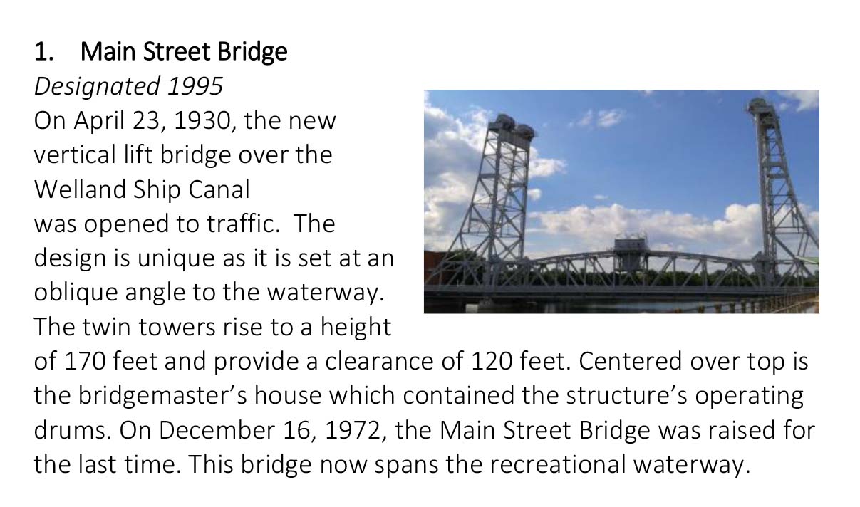