
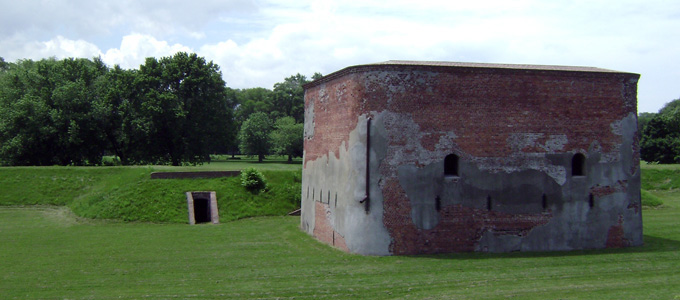
Fort George, located in Niagara-on-the-Lake, Ontario, was finished in 1802 and served as a base for the British army to protect Upper Canada from the United States during the War of 1812. The British Army while located at Fort George was led by a certain Major General Sir Isaac Brock until his death in October of 1812. The fort sits strategically along the Niagara River, protecting the mouth of the river to where it meets Lake Ontario. Fort George is also far enough upstream to avoid the heavy current and rapids that lead to Niagara Falls. Directly across the narrow river is the United States, which is another reason the British decided to place a military base in this location. In May of 1813, the fort was heavily damaged by artillery fire from Fort Niagara on the American side of the Niagara River, and then taken over by the Americans in the Battle of Queenston Heights. Following its recapture in December of 1813, the British began to rebuild the fort, however by the 1820's it was crumbling beyond repair, so the army moved on in favour of places such as Fort Mississauga. Fort George's stone powder magazine building, which survived the War of 1812, is the oldest building in Niagara-on-the-Lake and the oldest military building in Ontario.
In the 1930's, Fort George was reconstructed to its original form by the Royal Engineers, and designated as a National Historic Site of Canada. Today, the restored fort serves as a tourist attraction. Members of the public can enter Fort George and learn about the War of 1812, the daily life of soldiers and the community in the 19th century, and the 1800's military architecture which was used to design the fort.
Municipality:
Niagara-on-the-Lake
Local area name:
Fort George National Historic Site
Location description:
Short 15-minute walk Southeast from Queen Street in the downtown core of Niagara-on-the-Lake, to 51 Queen's Parade, Niagara-on-the-Lake.
Latitude: 43.2507° N
Longitude: 79.0612° W
Physical Dimensions
Length: 340 meters (0.34 km)
Width: 210 meters (0.21 km)
Surface Area: Approximately 53,700 m² (0.0537 km²)
Elevation
Highest Point: 88m
Lowest point: 82m
Fort George, constructed between 1796 and 1802 overlooks the Niagara River and the Canada – USA border. The Fort is a short walk from current downtown Niagara-on-the-Lake, and the town has now expanded right up to it, making Fort George a very easily accessible landmark. Fort George was used as a military base during the war of 1812, and was heavily bombed and mostly destroyed by the Americans during the battle of Fort George in 1813. The Fort was taken by the Americans, and then taken back by the British army in the Battle of Beaver Dams.
Fort George was restored in the 1930's, and is now used as an official historical site run by the non-profit organization The Friends of Fort George. The Fort is open daily May through October, and on weekends November through April. Tourists can pay a small fee to enter the Fort, and can "experience the sounds of the Fife and Drum Corps, witness the training manoeuvres of the 41st Regiment Infantry unit, taste food prepared over an open fire in the Officer's Kitchen, and witness musket and artillery demonstrations." (Friends of Fort George, 2016) The Fort also hosts larger occasions such as New Years and Christmas events, and the famous War of 1812 Battle re-enactment.
This report will outline the physical traits of the landscape and region, with a detailed description of the location using maps. Afterwards, a historical summary detailing the use of the land since 1800 will be given, and a more detailed summary of Fort George's current uses will be provided.
Fort George sitting on the West bank of the Niagara River, with Old Fort Niagara directly North on the American side. Northwest of Fort George is the town of Niagara-on-the-Lake, and even further Northwest within the Niagara-on-the-Lake Golf Club sits Fort Mississauga, another 19th century military fort.
Turning off of Queen's Parade and into the Fort George parking lot, you can not see the fort very well until you come through the trees. Here, the Street View camera is on the pathway to the main entrance to the fort. Since Fort George is so large, Google Street View was able to get the camera inside the Fort. To see more, move around in the interactive map above!
Fort George resides just outside of the town of Niagara-on-the-Lake, Ontario, and sits in a protected ecological zone. The photo below is taken from a map outlining the Ontario Greenbelt and other protected or monitored areas (Greenbelt Map, 2005). Using the legend also provided, you can see that Fort George sits in the Ontario Greenbelt Area as well as an area marked "Tender Fruit and Grape Lands."
The Niagara Region is famous for having a warm climate, and is home to plant species which do not exist in many other regions in Ontario because of this. Most notably, the vineyards for wineries and soft fruit tree farms that pepper the countryside are unique to the Niagara Region. Further from the flat farmlands, a variety of forests can be found. Some of the tree species which inhabit the Niagara Region include Beech, Ash, Birch, Oak, Maple, and many more (Government of Ontario, 2012). The Niagara Region has a very welcoming climate for plant and tree life, and because of this there is no shortage of greenery in the area.
As for wildlife around Niagara-on-the-Lake and Fort George, there are over 300 species of birds, approximately 25 species of water fowl and around 53 different mammals known to be in the area (Tour Niagara, 2015). Fort George is surrounded by a thin forest where many birds and small animals live, and is also in close proximity to the Niagara River and a much larger forest directly South; no doubt the homes for many other creatures. Most of the smaller wildlife is not afraid to get close to the tourists constantly milling around Fort George and Niagara-on-the-Lake, like the groundhog who decided to make his home in one of the Fort's berms as our class walked past.
According to Tour Niagara (2015), animals that used to inhabit the Niagara region include the Black Bear, the Mountain Lion, and the now extinct Timber Rattlesnake. These animals are no longer part of the area's current ecosystem.
The land around Fort George is fairly flat, besides the large bank overlooking the Niagara River. Due to the quick current of the Niagara River, there has no doubt been erosion over the years, however there was no evidence of any major changes.
Another geological feature that must be analyzed is the soil. By looking at the map and legend below provided by the Ontario Institute of Pedology (1989), there are many different soil types in Niagara-on-the-Lake, however Clay Loam till is the most common soil found near Fort George.
During the construction of Fort George at the turn of the 19th century, there were lots of changes made to the landscape. Because soldiers in the 1800's would only arrive on foot, lots of land barriers and obstacles were made in order to make life most difficult for the attacking party. Berms, hills and trenches were dug and created in strategic places around Fort George's perimeter (TripAdvisor, 2016). As you can see from the pictures attached below, the inside of the Fort was built up in order to create an artificial high ground, and the outside of the Fort was dug deeper in order to create an exaggerated low ground (Friends of Fort George, 2016).
Fort George overlooks the Niagara River from a high bank, where a few kilometers North lies Lake Ontario. The stretch of river where Fort George sits has remained relatively unchanged since the land was settled. Other than a few private docks and the Niagara-on-the-Lake Harbour, the river is not used very much, and there are a few reasons why.
The first reason is that the Niagara River also acts as a border between Canada and the USA, so crossing from one side to the other is actually not allowed, unless you check in with the proper authorities. Where Fort George sits, the river starts to open up its mouth into Lake Ontario. Because the Lake is a larger and more open space, the river is not used for recreation as much. The river also contains very strong currents, rapids, and much further South, waterfalls. Because of the strong tides, sailboats and swimmers do not wander much further South than the Niagara-on-the-Lake Harbour, just North of the shore of Fort George. Because of these strong currents, the river tends to take longer to freeze in the winter. However, the shore where Fort George sits is under 2 kilometers from Lake Ontario, making the river more apt to freezing than it would be closer to Niagara Falls where the current increases.
These tides and close proximity to the United States and Lake Ontario were some of the reasons why Fort George was built where it was; more information on this will be outlined in the "Historical Features" section which is yet to come.
The Niagara Region is one of the most Southern regions in Canada and has two Great Lakes on either side, helping the micro-climate remain one of the warmest in Ontario. The large water bodies help maintain a proper level of humidity, and because water absorbs a large amount of solar energy, the temperature of the Niagara Region remains relatively warm, for Canadian standards, during winters. (Hough, 2004)
According to Hough (2004), climates are largely affected by the level of urbanization within. In the Niagara Region, the nearest town to Fort George is Niagara-on-the-Lake, which is a tourist town, but by no means a large urban sprawl. Because of the large amounts of farmland, forests and rivers, this region falls into Ontario's Greenbelt, which means that the region is limited to certain industrial expansions, and is constantly monitored for factors affecting the environment.
Because of the inviting soil and warm climate, human-induced changes are very minimal. However, the effort made to conserve this climate and make proper use of it is large. The Niagara Region grows an abundance of soft fruit which requires warmer temperatures, and is most known for being the home of hundreds of vineyards, which produce grapes for the manufacturing of wine. The humidity and climate here are valuable to Ontario and Canada, and because we have recognized this, our best efforts have been made to keep our carbon footprint to a minimum.
Fort George was constructed by the British between 1796 and 1802. The Fort was designed to protect Upper Canada's capital city, Newark, which is now Niagara-on-the-Lake, and also house the Centre Division of the British army, led by Major General Sir Isaac Brock. The British had previously owned and used Fort Niagara which is directly across the river on the American side, but had to abandon it after signing Jay's Treaty.
In 1813, the Americans heavily bombed Fort George and then invaded by foot, forcing the British to retreat to present-day Burlington. 7 months later, the British recaptured Fort George and attempted to repair it, however it progressively fell into ruins. By 1815, the British had moved on to Fort Mississauga. The only building to remain intact from the American invasion was the powder magazine, which remains the oldest military building in Ontario.
In the 1930's Fort George was rebuilt by the Royal Engineers, and designated a National Historic site of Canada upon complete restoration. Today, the site serves as a tourist attraction run by the Friends of Fort George. The non-profit organization runs tours, demonstrations, and events.
Education / Interpretation:
The Friends of Fort George are the organization who run the Fort. The staff wear 1800's military dress, give tours of the fort and perform the occasional reenactment for the audience. Fort George also holds special events on certain days of the year, including the famous Battle of 1812 Reenactment where thousands of people attend to watch a participate. (Friends of Fort George, 2016)
Architectural Heritage:
The Stone Powder Magazine inside Fort George is the only building in the fort which still stands from original construction. Built in 1800, it is the oldest military building in Ontario (Friends of Fort George, 2016). The Powder House is a popular attraction when visiting the Fort, and is still in good shape.
The rest of the Fort has been completely restored in order to appear as it did before it was bombed in 1813. The blockhouses, officer's quarters and more have all been refurbished and filled with historical artifacts.
Recreational Uses:
The Fort is surrounded by public pathways where pedestrians can walk or bike around. The Fort also runs different events throughout the year in order to attract tourists and historical societies from around Ontario and the United States.
In 1781 the British Government purchased land from the Native Mississaugas (The Niagara-on-the-Lake Chamber of Commerce, 2000). After Canada became an independent nation, the land Fort George resided on belonged to the Canadian Military. The military used the land as a training base under the name Camp Niagara up until 1965, when they abandoned the location. The land is now owned by Parks Canada, and is managed by the Friends of Fort George.
The location falls into the Niagara Greenbelt and is a protected zone. Since Fort George's land is owned by the government and is in the Greenbelt, the land is maintained and monitored extensively.
Fort George is a short walking distance away from the downtown core of Niagara-on-the-Lake. The initial purpose of Fort George was to protect the town, but unfortunately they were both burned to the ground by the American invasion in 1813. As Niagara-on-the-Lake grew into a tourist destination over the past 75 years, Fort George began to take shape as a tourist destination as well. When the Friends of Fort George non-profit group began to manage the facility and run tours, Fort George grew even more and is presently a very popular family tourist attraction.
Back in the 1800's, Fort Mississauga also played a large part in how Fort George has developed into what it is now. When Fort George was recaptured by the British Army, the Fort was in pieces, so they decided to abandon it in favour of Fort Mississauga. If the British had chosen to rebuild Fort George, the Fort's appearance today would be very different, and it may have been used differently in between the War of 1812 and present day.
Contact information for The Friends of Fort George:
Email: giftshop@friendsoffortgeorge.ca
Phone: 905-468-6621
The Friends of Fort George
P.O. Box 1283
Niagara-on-the-Lake, ON
L0S 1J0
Contact information for Parks Canada:
Email: ont-niagara@pc.gc.ca
Phone: 905-468-6614
Alberti, M. (2008). Landscape Signatures. In Advances in Urban Ecology: Integrating humans
and ecological processes in urban ecosystems (pp. 93-112). New York: Springer. Brock
University Library Catalogue, EBSCOhost. Retrieved November 8, 2016.
Alberti, M. (2008). Hydrological Processes. In Advances in Urban Ecology: Integrating humans
and ecological processes in urban ecosystems (pp. 133-161). New York: Springer. Brock
University Library Catalogue, EBSCOhost. Retrieved November 8, 2016.
Canada National Archives (n.d.) Plan of Forts: George, Mississauga, Niagara. Retrieved November 1, 2016,
from http://dr.library.brocku.ca.proxy.library.brocku.ca/bitstream/handle/10464/10565/NMC-15014.jpg?sequence=1&isAllowed=y
Friends of Fort George. (n.d.). The History of Fort George. The Friends of Fort George. Retrieved September 19, 2016, from http://www.friendsoffortgeorge.ca/fort-george/hist...
Friends of Fort George (2016). Fort George National Historic Site. Retrieved November 7, 2016,
from http://www.friendsoffortgeorge.ca/images/sunset2.jpg
Friends of Fort George. (2016). Fort George National Historic Site. Retrieved November 10,
2016, from http://www.friendsoffortgeorge.ca/fort-george/inde...
Friends of Fort George. (2016). Fort Mississauga. Retrieved November 10,
2016, from http://www.friendsoffortgeorge.ca/images/mississauga.jpg
Government of Ontario. (2012). The Tree Atlas: Southwest region 7E-3. Retrieved November
10, 2016, from https://www.ontario.ca/environment-and-energy/tree-atlas/ontario-southwest/7E-3
Greenbelt Map (2005). Niagara Peninsula Tender Fruit and Grape Area [map]. Niagara Region,
Ontario: Government of Ontario. Retrieved November 8, 2016, from http://www.mah.gov.on.ca/Page190.aspx
Hough, M. (2004). Cities and Natural Process. London: Routledge.
Ontario Institute of Pedology (1989). Generalized Soil Map Regional Municipality of Niagara,
Ontario. Scale 1:100,00. Retrieved on November 11, 2016, from
http://sis.agr.gc.ca/cansis/publications/surveys/on/on60/index.html
Phillpotts, G. (1823). Plan of Forts George, Mississauga and Niagara, the Military Reserves, and
the Town of Newark.
Ridler, J. (2011). Battle of Queenston Heights. War of 1812. Retrieved September 19, 2016,
from http://www.eighteentwelve.ca/?q=eng/Topic/15
Stanley, G. F. (1950). The Indians in the War of 1812. Canadian Historical Review, 31(2), 145-
165. http://journals2.scholarsportal.info.proxy.library... v31i0002/ 145_tiitwo1.xml
The Niagara-on-the-Lake Chamber of Commerce (2000). About Niagara on the Lake. Retrieved
November 10, 2016, from https://www.niagaraonthelake.com/page/About_Niagara-on-the-Lake
TripAdvisor (2016). Photo: photos of the attraction. Fort George National Historic Site of
Canada Pictures. Retrieved November 7, 2016 from https://media-cdn.tripadvisor.com/media/photo-s/0b/6f/f6/cb/photos-of-the-attraction.jpg
Tour Niagara (2015). Fauna. Geology and Nature. Retrieved November 10, 2016, from
http://www.tourniagara.com/geologynature/fauna/
Wikipedia (2016). Fort George, Ontario. Retrieved November 11, 2016, from
This Local Landscape Report was prepared by Andreas Derksen for the Brock University course TOUR 2P94: Human Dominated Ecosystems on November 10, 2016.
All copyrights for cited material rest with the original copyright owners.
 Accessible
 TripClips
 Call before visiting
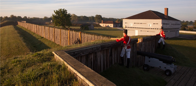