
In 1958 the Pen Centre opened its doors to the citizens of St. Catharines and the Niagara Region. It has had 4 renovations or expansions all within the last 21 years beginning in 1995 and the most recent being in 2011. The Pen Centre features over 180 different stores and services over its 1 million sq. ft. space. Just off highway 406 the Pen is easily accessible and is a large draw for both local residents as well as travellers nearby on the Q.E.W. The Pen Centre has approximately 10 million visitors each year and offers about 4,000 jobs. Thus is a huge source of income for St. Catharines, money that is partially put back into the shopping industry by the employees of the Pen. The Pen Centre has gone through 4 large renovations or expansions coming in 1995, 2002, 2004/2005, 2011. Recent talks of transforming the old Target into a Walmart is another way the Pen could potentially increase both revenue and job opportunities for locals and tourists alike. The Pen Centre underwent its first major renovation 1994 and had its most recent one on flooring and ceilings in 2011; this would also include a revamp of washrooms and light fixtures. The Pen Centre is a landmark and popular city center for many locals and tourists, creating money and jobs for the community.
Sources
"Walmart Buying 13 Former Target Canada Stores | Toronto Star."Thestar.com. N.p., 08 May 2015. Web. 21 Sept. 2016.
Nurun.com. "Pen Centre to Undergo $13M Interior Renovation." St.Catharines Standard. N.p., n.d. Web. 21 Sept. 2016.
Birkett, Jennifer. "Margaret Storm Jameson and the London PEN Centre:Mobilising Commitment1." E-rea Erea 4.2 (2012): n. pag. Web.
Local Landscape Report on The Pen Centre
William DiFrancesco
5466925
November 11, 2016
Municipality: Niagara Region
Local area name: St.Catharines
Other identifying names or descriptions: Glenridge / Merritton
Latitude and longitude: 43.1363° N, 79.2249° W
Physical Dimensions
Length (Property): Apprx - 680.32 meters (furthest distance)
Width (Property): Apprx - 443.10 meters (furthest distance)
Length (actual Mall): Apprx - 493.54 meters (furthest distance)
Width (actual Mall): Apprx - 267.09 meters (furthest distance)
Surface Area: 1,000,000 sq. ft.
Elevation:
Lowest: 117 meters Highest: 125 meters

The Pen Centre is considered to be one of the major hubs in the Niagara Region, with its 180+ stores and kiosks this is one of the pinnacle staples of St. Catharines. Located near both highway 406 and the QEW the Pen Centre is easily accessible for travellers and locals alike. Just a 10-minute drive from Brock University, the centrally located Pen caters to the many surrounding high school and University/College students. Prior to its creation the Pen Centre and surrounding area was used mostly as agricultural land, being a part of the greenbelt this land was a prime spot for farming. The Pen has been a landmark for many locals offering a variety stores and kiosks, making for a fun and easily accessible shopping experience.


Google Map
The ecology and physical features of this region are comprised of many and varied waterways, land formations, plants and animals all with their own history and impact on the story of the region. The vast amount of information about each aspect of the physical and ecological make up of this unique area is not easily summarized. The biota, geomorphology, hydrogeology and climate are all interconnected; making it difficult to separate the effects and impact that change the delicate state within which these features both draw from contribute to the state of the others.
The biota of this region is part of the Carolinian woodlands and has approximately 2200 species of plants trees, shrubs, birds, mammals, reptiles and amphibians, among them rare ones. There are many natural plants found in the rural spaces of the escarpment among them ferns and orchids, mosses and lichens, and tiny Eastern white cedar trees (Penney, 2012.)
Closer to the lakes, is an area ,known as the "golden horseshoe" or the "fruit belt", for the sun and farming in the region , supplies fruit and vegetables for the province , the country and our neighbours to the south. The area also is known as "wine country". Wines from Ontario are known around the world and have provided significant economic prosperity for the region and the province.
The region also contains Wetlands with , rushes, reeds, cattails and pondweeds, fish, amphibians, turtles, snakes and birds(Penney 2012). Plants and wildlife which are vulnerable to depletion of water, pollutants which flow through the groundwater and destruction at the hands of industry, urban living projects, human recreation and other influences. Woodlands are similarly vulnerable to these influences when man neglects to recognise the rare tree shrubs and ground cover that is often removed or abused through our use and through the cultivation of recreational spaces. The Niagara escarpment is a made up of limestone and plant life that has existed there for millions of years. Hough writes that ravines and valley lands like this one, host natural vegetation that protects the erosion of this kind of land form. The escarpment has been disturbed by the traffic that travels along the shores of the landform in the Welland Canal. The interference with the natural vegetation and terrain has encouraged greater erosion than nature alone would have dictated. Changes to the species have been a result of adaptations in the plants insects, waterfowl and wildlife which respond to the environment, food sources and environmental effect of climate change. There are many natural spaces in which are currently protected by the province so that the so called Green Belt will not be lost the latest development that current inhabitants determine.
The urban development in the area has changed the landscape and the use of land considerable over the last few centuries and Hough expresses his strong hope that someday the plan for the urban landscape will recognize that,
"The interrelationships of climate, geology and geomorphology, water, soils, plants and animals provide the fundamental ecological information on which environmental planning and management of land are based. At the broad level of spatial design the remnant natural and naturalized plant communities that occur all over the city require cataloguing and evaluation. Places that have habitat potential for plants and animals - patches of woodland or meadow, valleys and other linkages - should be integrated into the planning and social network of city places (Hough, 1984,p.94)."
 An aerial shot of the Pen Centre area in 1954, 4 years prior to its construction.
The landscape of the Niagara region is formed by an escarpment dating back thousands of years ago, when the Wisconsin glacier receded, creating the rock formation ridge between two lakes with land rich in minerals ( Giant's Rib , 2016). Other features of the geomorphology include Niagara escarpment a huge long ridge of rock which winds its way through the province far beyond this region. It is recognise as Unesco world biosphere reserve because of the efforts of local residents to preserve and conserve the area within the modern development which surrounds it . The valley where the Pen Center is located sits below the Niagara escarpment and has the protection of the landform from that location. Many quarries extracted limestone and sandstone. The layers of bedrock in the region hold many varieties of stone which reveal the changes which have occurred through time.
Transforming the rich fertile agricultural lands present before the conception of the pen centre, into the massive superstructure it is today. As a result of this destruction of rich earth previously used for farming, the Pen has gone through extensive development.Not much has changed the Pen Centre in terms of natural changes, however as a result of such a massive blacktop, recent changes have been made to the storm drains of the pen in order to account for weather run-off. (i.e. rain, snow, and mud) To get to the present day structure of the Pen, as with any large infrastructure the land prior to its use went through significant changes. Grading, leveling and excavations are just to name a few of these changes that have changed the view for residents of the Glenridge/Glendale area. The Pen with its unique layout has many levels and although it is no more than 2 stories in some places, it has a unique design to allow for easy access to all.
The hydrological feature of this area include the several major rivers, the Welland and Niagara rivers and Twelve Mile Creek with the Pen Centre situated between the Creek and the Welland Canal. These waterways were adapted with canals so that the routes to the larger waterways of Lake Ontario and Lake Erie could be accessed connecting one to the other. The other motivation was to find a passageway that did not require portage over land or travel into the United States to transfer good to Montreal and beyond. The canals mostly provided power for the mills in St. Catharine's (Middleton, Eyles, Chapple and Watson, 2009). In the urban center present new hydrological issues Marina Albertini (2008) explains that with pavement, cement and hard surfaces keeping water on the ground and storm drains that the swiftly removal of water and snow from urban streets we do not allow for the natural absorption of moisture from rain and snow in the environment. Where rain and snow lay in pools or piles in outlying areas farms and the forest, moisture can absorb into the ground, evaporate into the air and provide natural cooling through this process. Humans affect the hydrologic processes through our consumption of water, changing land cover as described above, building synthetic and unnatural infrastructures and introducing contaminants to the water system. The synthetic ground cover helps distribute contaminants to open waterways much more readily (Albertini, 2008).
"As a result, the amount of precipitation varies more, runoff increases, and changes occur in flow regimes, drainage pathways, and even the composition of the water and sediments. In urban watersheds, these modifications of the water cycle threaten hydrological functions and, ultimately, the human and ecological functions that depend on them" (Albertini 2008, p.144).
Climate
Production of greenhouse gases are part of natural processes and are essential however they are creating changes in our weather. Human activity is rapidly changing the concentration of greenhouse gases in the atmosphere. Since the early days of the Industrial Revolution carbon dioxide (CO2 ) levels in the atmosphere have increased by about 39%. The burning of fossil fuels coal , oil and natural gas, deforestation, , producing lime to make cement, treatment of garbage, sewage and other items in landfills. Production and use of fertilizers pesticides and other toxic waste products all contribute to global warming .The Intergovernmental Panel on Climate Change estimates that greenhouse gas levels are now higher than they have been anytime in the last 650,000 years. ( Jennifer Penney, 2012, P.8)
Urbanization in the valley below the escarpment has been steadily in progress since the early settlers arrived. In the modern day St. Catharine's is certainly no longer the open space it once was. In his book, Cities and Natural Process, (1984), Michael Hough explains the impact of urban changes on the landscape and the people who live there. He says that because of the many structures in cities which he refers to as "rough surface areas"(p.192), the cooling effect of wind is interrupted when the flow of air hits a building or other obstruction. Certainly the effects of city life have dramatically influenced the area around the Penn Center in St. Catharine's since the late 18th century. Hough also sites changes to related greenhouse gas effects. Toxins come from industry and materials like pavement, building materials, concrete, glass and plastics. These are just some examples of urban impact on the climate which Hough (1984), identifies (p.192, 193). Not only do pollutants affect heat and air quality, they affect the quality of the ground water, waterways and the landscape in and around St. Catharine's. Hough (1984) also identifies the problems with the modern obsession with "mechanical climate control"( p.194). As we have contributed to higher temperatures and poor air quality in the outdoor environment, we become more reliant on air conditioned indoor environments such a malls. Free air conditioning, both heating and cooling makes large temperature controlled spaces very attractive and desirable for people when weather is extreme(Hough, p.195).
Microclimate
St. Catharine's in in close proximity to several large bodies of water which Michael Hough (1984) says, store large amounts of solar energy and are known to heat up and cool down, slowly which has a cooling effect on the land surrounding them (p. 189). St. Catharine's enjoys a unique microclimate because of the cooling effect of close by Lake Erie and Lake Ontario. It is also protected on one side by the Niagara Escarpment. St. Catherine's has had a long history in agricultural success due in part to these natural effects of climate in the area. Since the European's arrived, the natural resources have been affected by the industrialization and urban growth in the area. Some of the specific impact of human-induced
Global warming means that temperatures have risen 1.3 degrees in the past 40 years and will continue to rise. Lightening, hails storms high winds and other extreme weather conditions affect the region. Strings of warm days, longer growing seasons and heat waves all impact the local climate. More rain falls year round but not as much in the summer. For some farmers these longer growing seasons and high temperatures may mean short term prosperity , but others farmers who raise livestock struggle to feed and water animals in a dry summer. Rainfall is on the rise year round however it falls less in summer then previously ( Penney, 2012) and provides less impact on the ground and in the atmosphere when temperatures are generally hotter. In Niagara, local grape growers find that the changes benefit certain varieties of grapes while others get heat and drought stress. Warmer temperature creates greater pesticide prevalence and a difference in the outcome of the taste their products. These changes can be blamed on life in urban centers and modern industrial overproduction as major influences from man.
ARCHEOLOGICAL INFLUENCES:
According to Alun Hughes in his report Shades of Reynoldsville and Decew Town: A history of Power Glen and Vicinity,(1980), the earliest known native population in this area were known as the Neutral Indians however in 1650 they were attacked and wiped out by the Iroquois Indians from the Finger Lake region. From that point until the mid to later 1700s, it was uninhabited, according to Hughes. The Canadian Encyclopedia states that the early inhabitants were Chonnonton tribe, an Iroquoian speaking native peoples who were referred to as the Neutrals. They were attacked and killed in the mid 1650's by the Haudenosaunee people and many had died earlier in the small pox epidemic. The Haudenosaunee people remained there and they still inhabit this area today, many on the Six Nations Reserve and elsewhere.
LAND USE HISTORY:
The Early European settlers of this region arrived to find that the land was made up of large open fields that were close to water and had fertile soil which was the perfect landscape for farming. This area, formerly called "The Twelve" because of the Twelve Mile Creek which ran through it, was later known as Shipman's Corners and served as a popular stop for travelers on the route previously developed by the natives, along the base of the escarpment (Corporation of the City of St. Catharine's, 2014). As the land was settled, farmers produced grains which were milled into Grist. Lumber Mills were built along with the Grist Mills to meet the growing need for the building material (Corporation, 2014) The Penn Center site is located squarely between the Welland Canal and the Twelve Mile Creek which both were key in the success of these industries in the region. When the war of 1812 led to the destruction of other areas closer to the Canada US border, these businesses thrived and grew along Twelve Mile Creek because the area around Shipman Corners currently St. Catharine's was more protected than the border region. This factor made it an attractive place to settle and find work after the war (Corporation, 2014). In 1815, a wharf was created at Shipman's Corners and further prosperity followed. Mineral springs were discovered in the region, particularly along Twelve Mile Creek and salt which was not easy to get at the time was a very successfully produced and the region benefitted when the profits made by many in the business went back into the economy in the region. Historical Narrative of Early Canada, 2013).The salt production helped the area become known as a place to renew health and drew visitors. Farmers had access to salt locally and no longer had to rely on the US supply. Salt became a major export in the country, and continues to be a big business for this country and that area today (Historical Narratives, 2013).
Metal and machines were soon manufactured in the region and then came creation of the Welland Canal ,which was meant to connect the Lake Ontario north to the Welland and Niagara Rivers and beyond to Lake Erie; providing needed water supply for the mills and opening up the transportation routes for incoming and outgoing goods. The DeCew hydroelectric station was developed and late in the century Hughes, 2008). Niagara and St. Catharine's Central railways were laid, among others and soon the Welland Canal was could be crossed by rail (Jackson and Gayler, 2016).The area expanded even through the World wars and afterwards the railways and industry continued to prosper. After the war the automobile changed the area as more demand for residential property followed and the area recovered. The natural valley where the Penn Center is located was no longer the only area of expansion, the boundaries in all directions were pushed outward five times during the 1950s (Corporation, 2014). The downtown area which was west of the valley was not as much a focal point of retail after the Penn center was built in the 1950's with other and other shopping centers taking their share of the business Corporation, 2014). The opening of the University in 1964 drove the need to serve a new population for housing and retail as well as entertainment further urbanizing the area around the Penn Center.
Over time some of the natural spaces have been preserved such as the Bruce Trail and others returned to former uses like Merritt Trail which was an old canal route. Cycling, walking and riding trails along the new canal and old railway lines exist today. The more the population grew and the industry thrived, the impact of the industrial and agricultural use of the land caused barriers to natural wild life and fish in the area. Currently significant erosion has affected the surface material of soil and vegetation which exist on top of the bedrock in this area. The effect of this condition is that ground water does not filter through this material and so it cannot filter out bacteria, sediment and other contaminants which are increasingly a problem. In some areas, water filters directly through cracks in the bedrock allowing contaminated water to be deposited in the groundwater we which is part of the treated water we use daily Niagara Peninsula Conservation Authority (NPCA), 2000).The authorities report (2000), concludes that,
"Changes in the quality of groundwater and the water that enters Twelve Mile Creek and other waterways in the area determine what kinds of plants and wildlife will be supported by this watershed. Some of the changes are natural and expected while others result from human interference with nature."(p. 12).

Another aerial shot of the Pen area, this one taken in 1934 showing it fantastic agricultural plot.
Aside from its construction in 1958 the Pen hasn't provided much other than a unique shopping experience for locals and tourists. It acts as a local gathering spot for teens & university students, shopaholics, foodies, families, the elderly, showing the real sense of community that can be offered. The Pen acts as the glue for the surrounding community, not only in terms of keeping a steady income fore more than 4,000 people but as a local gathering spot for an entire community. Personally having been able to experience this wonderful mall and witness the experiences that occur within, i am astonished at what a simple mall can do for a community, and their interactions.


The Pen Center is owned by and belongs to the zoning C4 called " Major Commercial ". The Zoning By-laws govern the use of the space and owners must adhere to the regulations. The Urban planning department of the city governs very specific details of building , safety, landscape , accessibility, property upkeep among other details. Public access during business hours is of course permitted inside the general building and stores.
There have been numerous renovation and upgrade to the property since it was first built in the 1950"s . In 2011, the Pen Centre's latest renovation of the mall's common area to create a brighter, refreshed and greener shopping experience. The environmentally and shopper-friendly redesign was inspired by Niagara's vineyards, parks, gardens and trails. The renovation included the addition of three new skylights that have significantly improved natural light, brighter energy-efficient lighting throughout, improved air circulation, new washroom facilities with all hands-free energy efficient amenities and a hot-water-on-demand system as well as new recycling stations including organic waste, complete the environmental upgrades.
The Pen is owned and operated by 20 VIC Management Inc. They run the mall, and are the contacts for any of then Pen inquiries.
The Pen Centre is in a very unique location, just below the escarpment and situated between 12 Mile Creek, and the Welland Canal this massive property is in a prime spot. Not only is it near two significant waterways, it is also very accessible by car and foot. Located just of the 406 and near the QEW highways, the Pen sees a lot of traffic as a result of its clear view from the highway. Malls of this magnitude were often overlooked in Canadian boarder cities, simply due to the dollar, and how merchandise was way cheaper and more easily accessible in the U.S. Without the newer infrastructure the Pen area has increased its accessibility and looks to gain a whole lot more with talks of a Go train expantion to the Niagara region.
Pen Centre Mall Administration Team
CENTRE MANAGER
John Bragagnolo
T: 905.704.4161
RETAIL MANAGER
Iavor Perduhov
T: 905.704.4170
MARKETING DIRECTOR
Helen Edwards
T: 905.704.4159
OPERATIONS MANAGER
Norbert Gaudette
T: 905.704.4166
SECURITY MANAGER
Mike Reid
T: 905.704.4169
SPECIALTY LEASING & PARTNERSHIPS MANAGER
Daniela Vicino
T: 416.875.0581
MARKETING COORDINATOR
Tina Dienesch
T: 905.704.4157
GUEST SERVICES SUPERVISOR
Wendy Tufts
T: 905.687.6622
COMMUNITY BOOKINGS/DONATIONS/SPONSORSHIP REQUESTS
Danielle MacDougall
T. 905.704.4164
GUEST SERVICES
T: 905.687.6622
Toll Free: 1.800.582.8202
LITERATURE CITED
About Our City. (n.d.). Retrieved November 13, 2016, from http://www.stcatharines.ca/en/experiencein/AboutOurCity.asp
Birkett, Jennifer. "Margaret Storm Jameson and the London PEN Centre: Mobilising Commitment1." E-rea Erea 4.2 (2012): n. pag. Web.
Gayler, H. J., & Jackson, J. N. (n.d.). St. Catharines. Retrieved November 13, 2016, from http://www.thecanadianencyclopedia.ca/en/article/st-catharines/
History of the City. (n.d.). Retrieved November 13, 2016, from http://www.stcatharines.ca/en/governin/HistoryOfTheCity.asp
Nurun.com. "Pen Centre to Undergo $13M Interior Renovation." St. Catharines Standard. N.p., n.d. Web. 21 Sept. 2016
Shaping the Escarpment. (n.d.). Retrieved November 13, 2016, from http://www.giantsrib.ca/shaping-the-escarpment/
The Niagara Escarpment | Bruce Trail. (n.d.). Retrieved November 13, 2016, from http://brucetrail.org/pages/about-us/the-niagara-escarpment=
Walmart Buying 13 Former Target Canada Stores | Toronto Star." Thestar.com. N.p., 08 May 2015. Web. 21 Sept. 2016.
http://thedirtyhandsproject.com/pdf/12%20mile%20creek%20strategy2%20.pdf
https://npca.ca/sites/default/files/TwelveMileCreek_WatershedReportCard.pdf
https://npca.ca/sites/default/files/WQREPORT2016.pdf
http://www.tbhs.ca/images/uploads/History_of_Power_Glen.pdf
http://www.thecanadianencyclopedia.ca/en/article/st-catharines/
http://www.stcatharines.ca/en/experiencein/AboutOurCity.asp
http://www.stcatharines.ca/en/governin/HistoryOfTheCity.asp
http://www.stcatharines.ca/en/buildin/resources/Zoning-By-Law.pdf
http://www.uppercanadahistory.ca/simcoe/simcoe4.html
https://www.niagararegion.ca/government/planning/pdf/climatechangerport.pdf
http://brucetrail.org/pages/about-us/the-niagara-escarpment
http://www.utsc.utoronto.ca/~eyles/pdf/Niagara%20Field%20Guide%202009%20May%20GAC%20Toronto.pdf
https://www.stcatharines.ca/en/buildin/Zoning.asp?_mid_=17123
IMAGE LINKS
https://brocku.ca/maplibrary/airphoto/1954/JPEG/4306-234.jpg
http://www.thepencentre.com/pages/thepencentre-about-us
http://www.thepencentre.com/pages/thepencentre-contact-us
http://www.20vic.com/propertyPDFs/1112/pen-centre.pdf
This Local Landscape Report was prepared by Will DiFrancesco for the Brock University course TOUR 2P94: Human Dominated Ecosystems on November 11, 2016.
All copyrights for cited material rest with the original copyright owners.
 Accessible
 TripClips
 Call before visiting
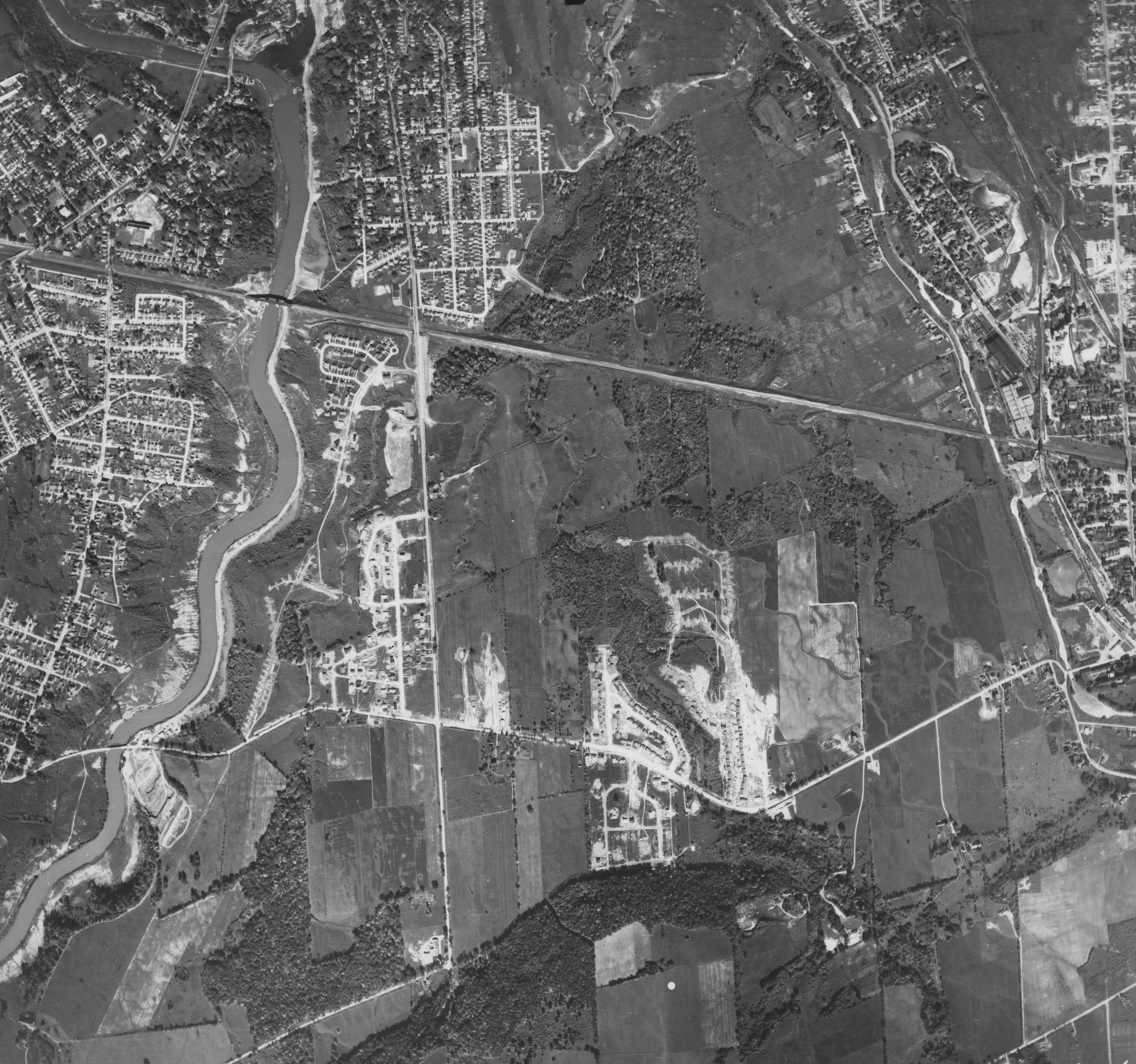